Saturday, March 10, 2007
Wednesday, December 20, 2006
It Starts Again
As 2006 draws to a close and SDS sets in, the time has come to start planning for the 2007 chase season. The chase team this year will be made up of myself and my great friend, Jake. We will begin our treck westward around May 5, depending entirely on atmospheric conditions and when our final exams are scheduled. It could be days before, or it could be weeks later; Mother Nature will decide. It will take about three days of travelling just to get into chase territory, with the third travel day being a potential chase day. Then we will chase around for a week or so, and schelp back to boring Massachusetts.
We will be documenting the snot out of everything. Jake will man the camcorder, I the trusty Nikon DSLR. The final product will be a storm chasing DVD so extravagent, so outlandish, so amazing, that it will blow away all precedents. You'll see. Blog posts will recount our exploits step-by-step, and you will be able to follow along with realtime GPS tracking and a dashboard webcam. Just you wait!
We will be documenting the snot out of everything. Jake will man the camcorder, I the trusty Nikon DSLR. The final product will be a storm chasing DVD so extravagent, so outlandish, so amazing, that it will blow away all precedents. You'll see. Blog posts will recount our exploits step-by-step, and you will be able to follow along with realtime GPS tracking and a dashboard webcam. Just you wait!
Friday, June 23, 2006
Day 6 Summary - The Grand Finale
Waking location: Lamar, CO
Sleeping location: Denver, CO
Distance travelled: Your guess is as good as mine
Short summary: Had fun with two LP storms; stared down the gullet of another HP beast
Long summary
What a great day for a chase tour finale. We travelled straight north out of Lamar for the entire day, meeting up with a beautiful, extremely high-based LP storm around 5:30 just north of Scottsbluff. Like every other LP storm we encountered, it ran into dry air and promptly shrivelled up.
We went further north again and intercepted another ridiculously high-based storm just suspended in the air. As we watched from the southeast it developed a very strong RFD cut that nearly killed the storm, but it slowly rebuilt its base. As we travelled north yet again, it became apparent why; looking back on the storm from the northeast, rock-hard updraft towers were boiling up into the atmosphere. It looked rather ridiculous, with these massive updraft towers so high off the ground just slamming into the jet stream and racing westward. That thing didn't quit sucking air for another couple of hours.
As you probably guessed, we again travelled north to meet up with a supercell screaming southwest towards us. We had watched this storm develop on radar over the past hour or two, thinking it out of reach, but it was trucking southward and by the time we reached it, it had developed a massive shelf cloud and was gusting like nobody's business. It was definitely supercellular, with the rain core wrapping fully around the rapidly rotating meso, totally obscuring any chance of possibly seeing a tornado, had it been able to produce one. This storm then gusted out and proceded to race with us back southward.
The motion along the leading edge of this storm was unlike anything I've ever seen. The gust front was churning and scouring the atmosphere. Little rotating eddies created all kinds of rotating clouds. Standing a few miles in front of the beast, you would feel a warm southeast wind at your back being sucked up into the storm. Then it would be calm, as the storm approaches and the air is literally rising straight up into the monster. Then the cold outflow wind hits your face and kicks up dust. That's your cue to get out of the way.
What an experience. We're on the way back to Denver tonight, and I fly home tomorrow. Thanks to Roger, Dave, Steve, and everyone at Silver Lining Tours for an amazing week. Given the conditions and 2006's dreadful reputation, I could not have asked for anything more. The best of luck to everyone in the high plains tour next week; it looks like a Death Ridge is approaching that might send you packing to Canada looking for storms.
Photos
I have lots of good photos. These are coming soon.
Final Final Thoughts
- Final tally: we saw 10 Wal-Marts and 18 Pizza Huts (all data are considered preliminary).
- I don't want to go home!
- I think I may puke if I have to ever eat fast food again.
- Watch for a "Best Of" post with all the best photos post-processed for your enjoyment.
- Time to start getting ready for the 2007 chase season.

Day 5 Summary
Waking location: Great Bend, KS
Sleeping location: Lamar, CO
Distance traveled: 603 mi.
Short summary: Got on several tornado-warned storms; was chased by an HP beast; core-punched a little bit
Long Summary
Today was another frustrating chase day of 2006, but we did as well as we could have done, given the situation. We did not miss anything major, since most of the “tornado” reports today were likely false. From everything we saw, the conditions were not in place at all for the formation of tornadoes. That being said, we did get to see some awesome gust-front action.
We went west from Great Bend along I-70 and into Liman, Colorado. I forget exactly what happened here. I know we passed through Liman several times after that, traveling north to catch some cells that quickly died, and then we went back south on some tornado-warned cells that quickly gusted out and went linear.
That was when the fun began. We ended up on the leading edge of a massive gust front. We stopped to photograph it for a bit, but as the hail core came up over the next hill, Roger yelled “We gotta go! We gotta’ go now!” and oh how we went. We blasted ahead of the massive high-precipitation beast of a storm that was bright green in its center. That’s an indicator of large hail; Roger was very eager to stay in front of it after all the hail damage the van received last week. This thing was massive, and was bearing down on us quickly. Looking behind the van, the shelf cloud looked like a the mouth of a giant monster ready to eat the van.
Out in front of this storm, the winds were gusting in a straight line almost at the speed of the van. Those were straight-line winds of fifty, maybe even sixty or seventy miles per hour! We were racing along with the wind to our back, and blowing dust decreased the visibility to zero at some points. We also saw many, many gustnadoes. Cows, too.
We went further south, out of the path of all that garbage, to intercept another line of garbage. An embedded meso in the line gave the storm a tornado warning, with first indications being the tornado was spotted on the ground. We core-punched that storm through heavy rain, wind, and some hail, and drove right underneath the rotating mesocyclone. Short of being on a roller coaster, I didn’t previously think there was any other way to get such an adrenaline rush while sitting down.
Eventually the tornado warning was dropped. We went south and then east through a squall line twice, but turned around the second time when all chances for a tornado had gone to zero (not that there was any chance to begin with).
For all the crappy storms out there today, I think we did quite well. The pictures definitely confirm that.
Photos
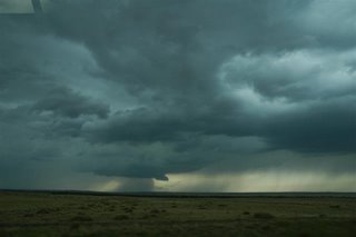
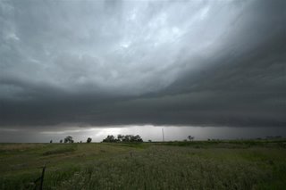
This is a suspicious lowering we spotted in a storm early on.
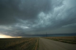
This is the first good view we got of this massive storm. It has already taken on a shelf cloud and a gusted-out appearance.
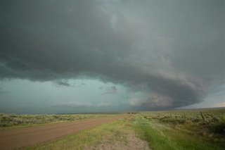
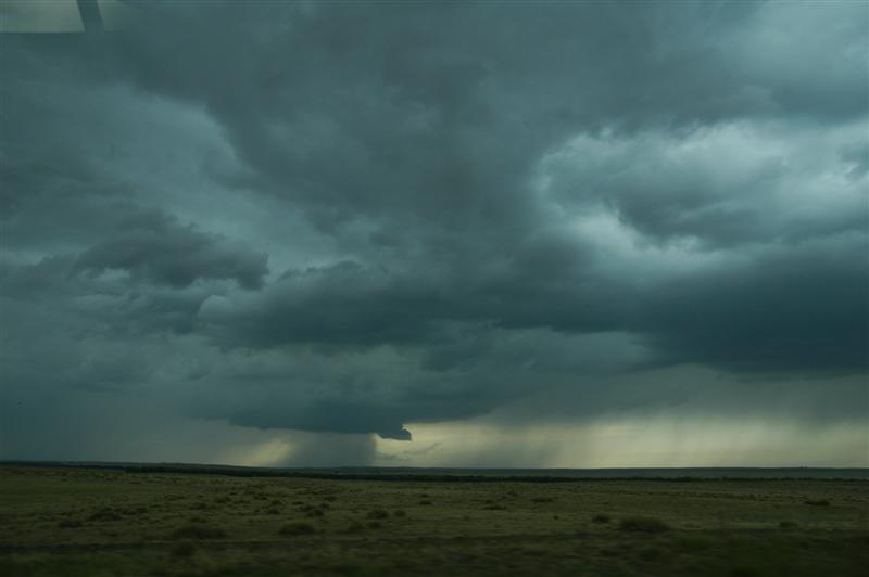
Soon it started bearing down on us. Notice all the bluish-green under that thing? Hail, hail, and more hail.
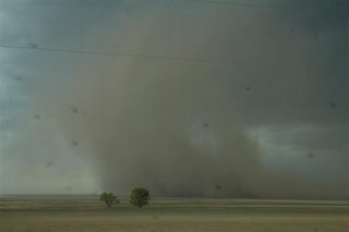
This is a huge gustnado that kicked up tons of dust when it died.

There was all kinds of vorticity along the gust front. The movement in the clouds here was tremendous, but it was nothing dangerous.
Here's one more look at this monster. Amazing structure.
Final Thoughts
Sleeping location: Lamar, CO
Distance traveled: 603 mi.
Short summary: Got on several tornado-warned storms; was chased by an HP beast; core-punched a little bit
Long Summary
Today was another frustrating chase day of 2006, but we did as well as we could have done, given the situation. We did not miss anything major, since most of the “tornado” reports today were likely false. From everything we saw, the conditions were not in place at all for the formation of tornadoes. That being said, we did get to see some awesome gust-front action.
We went west from Great Bend along I-70 and into Liman, Colorado. I forget exactly what happened here. I know we passed through Liman several times after that, traveling north to catch some cells that quickly died, and then we went back south on some tornado-warned cells that quickly gusted out and went linear.
That was when the fun began. We ended up on the leading edge of a massive gust front. We stopped to photograph it for a bit, but as the hail core came up over the next hill, Roger yelled “We gotta go! We gotta’ go now!” and oh how we went. We blasted ahead of the massive high-precipitation beast of a storm that was bright green in its center. That’s an indicator of large hail; Roger was very eager to stay in front of it after all the hail damage the van received last week. This thing was massive, and was bearing down on us quickly. Looking behind the van, the shelf cloud looked like a the mouth of a giant monster ready to eat the van.
Out in front of this storm, the winds were gusting in a straight line almost at the speed of the van. Those were straight-line winds of fifty, maybe even sixty or seventy miles per hour! We were racing along with the wind to our back, and blowing dust decreased the visibility to zero at some points. We also saw many, many gustnadoes. Cows, too.
We went further south, out of the path of all that garbage, to intercept another line of garbage. An embedded meso in the line gave the storm a tornado warning, with first indications being the tornado was spotted on the ground. We core-punched that storm through heavy rain, wind, and some hail, and drove right underneath the rotating mesocyclone. Short of being on a roller coaster, I didn’t previously think there was any other way to get such an adrenaline rush while sitting down.
Eventually the tornado warning was dropped. We went south and then east through a squall line twice, but turned around the second time when all chances for a tornado had gone to zero (not that there was any chance to begin with).
For all the crappy storms out there today, I think we did quite well. The pictures definitely confirm that.
Photos
This is a suspicious lowering we spotted in a storm early on.

This is the first good view we got of this massive storm. It has already taken on a shelf cloud and a gusted-out appearance.

Soon it started bearing down on us. Notice all the bluish-green under that thing? Hail, hail, and more hail.
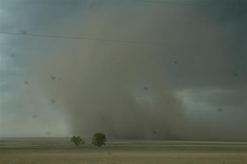
This is a huge gustnado that kicked up tons of dust when it died.
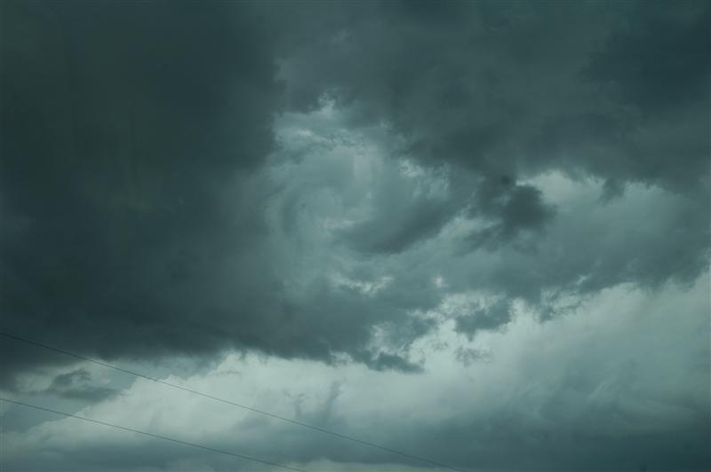
There was all kinds of vorticity along the gust front. The movement in the clouds here was tremendous, but it was nothing dangerous.

Here's one more look at this monster. Amazing structure.
Final Thoughts
- "What a beast!"
Thursday, June 22, 2006
Subscribe to:
Posts (Atom)